Trenalia

Spain's trains on a map, in near real time.

Trenalia brings together in one place the positions, delays, timetables and incidents published by Renfe, ADIF and other open sources, and explains them clearly. Check timetables, plan a journey with connections or ask Trenalito. It is an independent, non-profit project.

It is an experimental tool for information only. Positions and times are estimates. It is not for driving trains or for making safety decisions.

Most delayed trains right now

--:--
TrainDestinationNext stopDelay
Connecting to Trenalia…
— trains on the map — delayed by 5 min or more — median delay

Real data read just now from the Trenalia server.

Rail information already exists. The hard part is finding it and making sense of it.

Train positions are on Renfe's live viewer; Iryo and Ouigo delays, on ADIF's station boards; timetables, in official files; incidents, on another page; weather warnings, on AEMET. Trenalia puts it all on a single screen, snaps positions onto the track and makes clear what is data and what is an estimate.

It is a personal project, free and ad-free, designed for people who travel, people who follow the railway as a hobby, people who work in it and people who want to use its data.

What you can do

One website, on your phone or computer, with six main pieces. Further down you will find them sorted by what you are looking for.

  • Live map

    Where every train is and how late it is running, with its position snapped to the track.

  • Timetables and journeys

    Every direct train between two stations on any day, and how to get there with connections.

  • Platform view

    Departures and arrivals for any station, with countdown, delay and platform.

  • Trenalito

    An assistant you can ask in your own words about trains, delays, timetables and journeys.

  • Incidents, hazards and alerts

    Network incidents, weather, wildfires and earthquakes near the line, and alerts calculated by Trenalia.

  • History and open data

    How each train usually runs, punctuality, monthly reports, API and downloads.

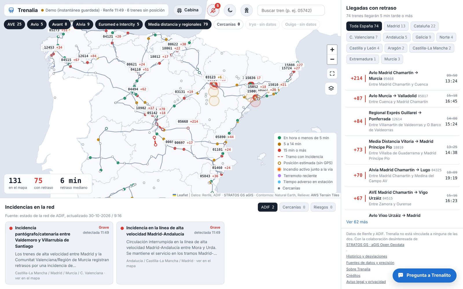
Map of Spain with trains coloured by delay, service filters and the list of delayed arrivals

In five languages (Spanish, English, French, Italian and German), with light or dark mode. The map remembers where you left it when you come back from other screens.

New

Trenalia on your phone, without app stores

Trenalia installs as an app straight from your browser: free, without signing up and without going through any store. It opens full screen with its own icon and has shortcuts to “Platform” and “Timetables”.

  • iPhone and iPadOpen trenalia.org in Safari, tap Share and choose “Add to Home Screen”.
  • AndroidIn the ☰ menu choose “Install on your phone” and tap “Install app”. You can also use the Install option in the browser menu.
  • trenalia.appIf you visit that address on your phone, you are offered the installation straight away. It never installs by itself: you always confirm.

Without a connection, it shows the last saved copy of the pages you have already visited, with a clear “Offline” notice: that data may be out of date. From the menu you can delete the data stored on your device at any time.

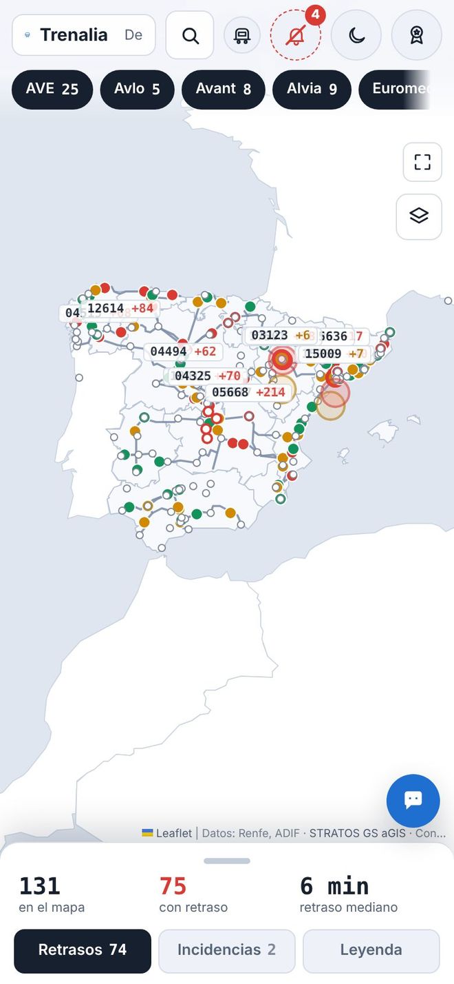
Trenalia on a mobile phone, with the map and the bottom panel

One network, different needs

Trenalia's features, sorted by who uses them. Choose your profile:

01

Travellers

For people who take the train every day or now and then: when it leaves, whether it is late and whether you will make your connection, before you check with your operator.
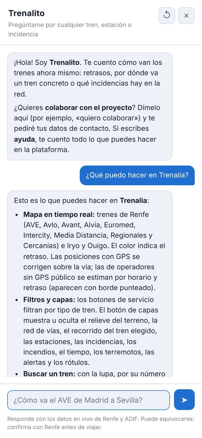
Trenalito chat on a mobile phone explaining Trenalia's features

Today's timetable

Every direct train between two stations on the day you choose, grouped into early morning, morning, afternoon and night, with journey time and stops. Past departures are dimmed and the next one is highlighted.

See timetables

How to get there, with connections

Combinations with up to three changes, with times, the margin for each connection and the live delay of trains already running. You can share the journey or add it to your calendar.

Plan a journey

Follow your journey

With “Set course”, Trenalia stays with you: time and platform before you leave, how far to your stop and a warning if a connection gets tight or is missed, with the option to look for another combination.

Platform view

Departures and arrivals at your station, or the nearest one, with countdown, delay and platform. At night it already shows the first trains of the morning.

Open the platform view

Alerts for your train

Follow a train and Trenalia lets you know when the delay reaches the minutes you choose, when the platform changes or when you are getting close to your station, while the website is open.

Indicative compensation

Based on the known delay, what compensation you might be entitled to under the rules published by each operator. It is only a guide: the operator's decision is what counts.

Ask Trenalito

Write the way you talk: “How do I get from Madrid to Seville tomorrow?”, “Timetables from Atocha to Aranjuez this afternoon”, “Are there any incidents in Catalonia?”. It answers with timetables and live data, takes you to the page with all the options, and you can rate each answer with 👍 or 👎.

It uses artificial intelligence (Claude, by Anthropic, with backup providers) and can make mistakes. Conversations are not stored; if you rate an answer, the question is saved without personal data to improve the assistant.

Talk to Trenalito
02

Rail fans and the curious

For people who enjoy watching the network move, or simply want to know which train just went past their window.

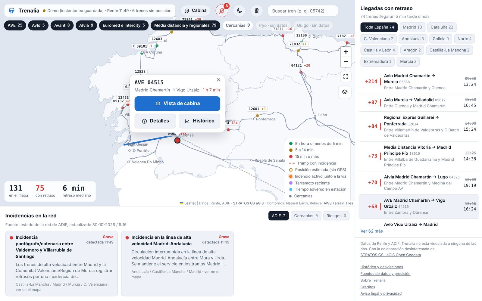
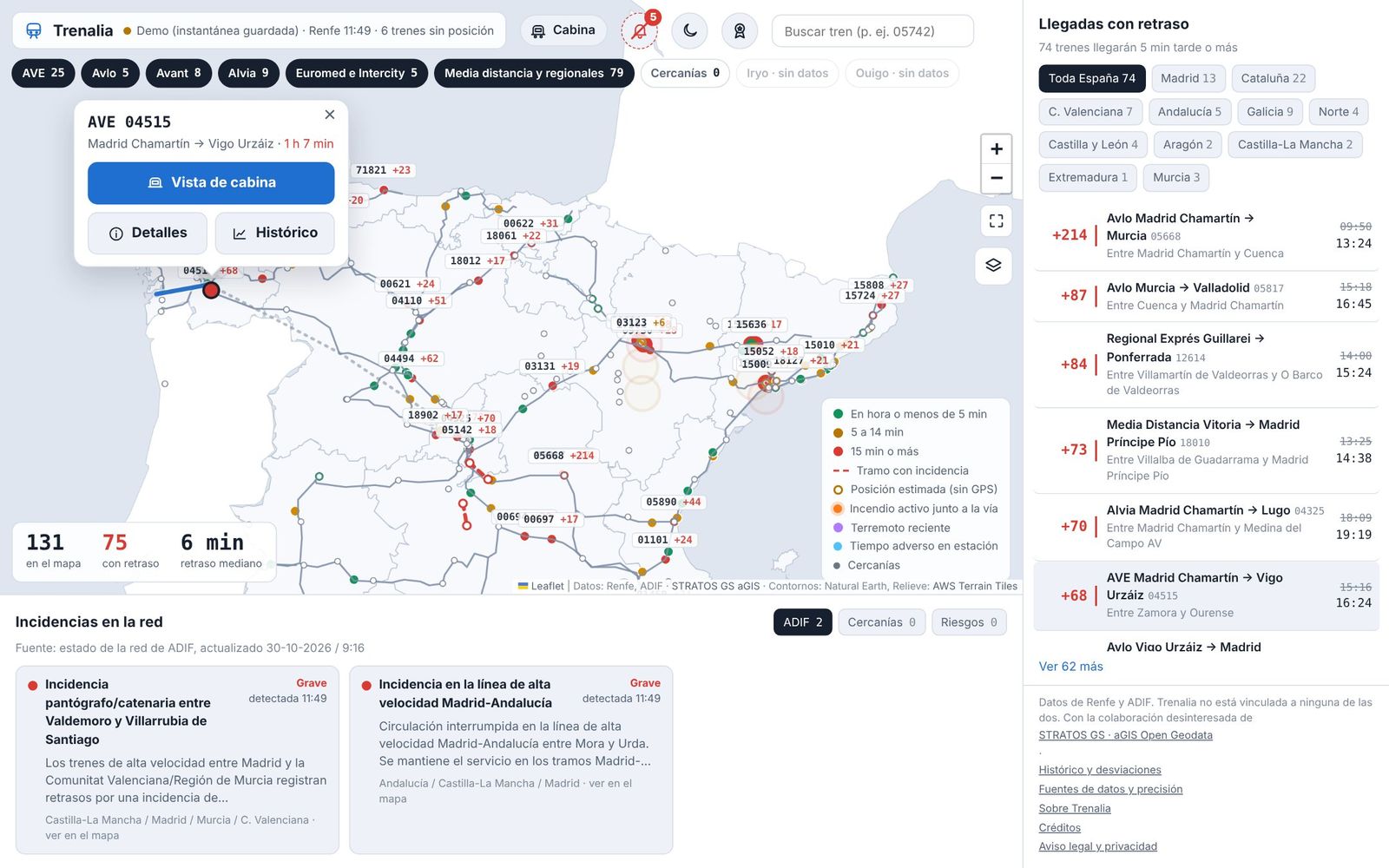
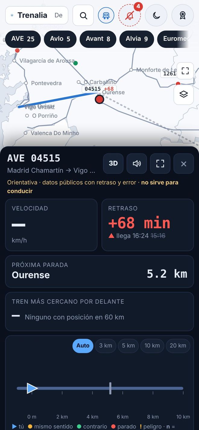
Menu for an AVE with the Cab view, Details and History buttons over its route Cab view on a mobile phone with the speed, the delay, the next stop and the track ahead

Live map

AVE, Avlo, Alvia, Euromed, Intercity, Media Distancia, regional, Cercanías and Rodalies trains, coloured by delay, with filters by service and by region.

Open the map

Positions on the track

Renfe's GPS is snapped to the real track and smoothed. Trains without public GPS, such as Iryo and Ouigo, are estimated from their timetable and drawn hollow. Every position shows its uncertainty.

Tap a train

Stops, timetable, delay, platform and position accuracy. Its route is drawn on the map: the part already covered in grey and what is still ahead in blue.

Cab view and 3D

What lies ahead of and behind the train: other trains, stations, incidents and hazards. With the gradient profile calculated from the IGN terrain model and a 3D view with the relief.

More operators and layers

FGC and Metro Bilbao trains, Euskotren delays and the status of each Rodalies line. Layers for infrastructure (single or double track, electrification, gauge, ERTMS, maximum speed), relief, weather, wildfires and earthquakes.

How does it usually run?

Look up a train and compare today's delay with its average over previous days, stop by stop.

See the history

The cab view is for guidance only: it uses public data with delays and a margin of error. It is not for driving trains.

03

Rail industry professionals and companies

For people working at operators, in logistics, freight or passenger services: an overview of the network with measured history and the sources in plain sight.

Close-up of the map in Galicia with the delayed arrivals panel and network incidents

Punctuality

Share of arrivals with 5 and 15 minutes' delay or less, by product, time of day, day of the week and route, over 7, 30 or 90 days.

See punctuality

Where time is lost

The sections between stops where trains lose or recover the most time, with the option of drawing them on the map.

Incidents and their impact

Every ADIF and Cercanías incident from start to finish, with its cause, its duration and an estimate of the trains affected and the minutes accumulated.

Monthly report

The month's punctuality by product, corridor and week, worst sections and incidents, compared with the previous month. Print it, save it as PDF or download it as CSV.

See the report

Supply and freight

Trains per operator on 14 corridors, a freight market panel with official CNMC figures, and network parameters useful for freight (axle load, loading gauge and maximum train length).

Timetable changes

Every hour the official timetables are compared to detect trains that have been cancelled, added or rescheduled for today and the coming days.

The analysis is in the map's ☰ menu → “Analysis”. Punctuality is measured with Renfe trains that publish GPS; the impact of incidents is an estimate by Trenalia, not official data.

04

Developers, researchers and media

Everything the website shows is also available as data, to build with, study or report on what happens on the network. Just credit the source.

# Public API, no key
GET /api/v1/trains?min_delay=15
# MCP server for AI assistants
https://trenalia.org/mcp

Public API v1

Read-only, no key and with CORS: trains, stations and their boards, incidents, hazards, alerts, timetables and journeys. Documented with OpenAPI, with texts in five languages.

See the documentation

MCP connector for AI

Connect Claude or another MCP-compatible assistant and ask it about trains, timetables, journeys, punctuality or incidents using Trenalia's data.

How to connect it

Open data

Monthly CSV downloads of journeys, sections and incidents, under a CC BY 4.0 licence and without personal data. Also feeds in GTFS‑Realtime format.

A board for your website

A station's departures or arrivals, ready to embed in any page with an iframe, in light or dark mode and in five languages.

Public validation

How accurate Trenalia is: the delay shown compared with the observed arrival, the status of the models and the outcome of the alerts.

See the validation

Free software

Trenalia's code is free software under the GNU GPL v3 or later.

See the licence

05

Public bodies and emergency managers

A view of the network in context, to understand what is happening and where, alongside the official channels.

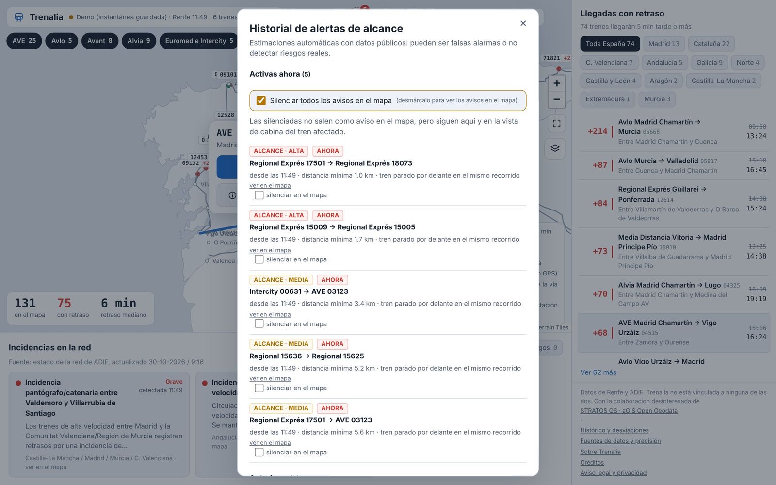
History of rear-end conflict alerts with the active alerts and the box to mute them

The network at a glance

Trains, delays and incidents across Spain on one screen, with the trains that will arrive late grouped by region.

Sections at risk

AEMET warnings, wildfires detected by satellite, fire danger, earthquakes and road closures near the line, with the trains that will pass through in the coming hours.

Network alerts

Stopped or very slow trains, sudden jumps in delay, possible temporary speed restrictions and abnormal drops in electricity demand as a warning sign.

Rear-end conflict alerts

When two trains with a reliable position get too close on the same line, with a review of what happened afterwards. By default they do not pop up on the map; the bell keeps the active ones and their history.

These are estimates by Trenalia using public data, without access to signalling: there may be false alarms. They are not ADIF warnings and are not for railway safety.

What open data allows today, and what better data would allow

Today

  • Renfe long and medium distance: GPS position and delay every 15 seconds.
  • Cercanías and Rodalies: positions and service notices as open data.
  • ADIF: network incidents and station boards covering all operators, when available.
  • Iryo and Ouigo: they do not publish GPS. They are placed using their timetable and, when station boards are available, their actual delay.
  • Other operators: positions of FGC and Metro Bilbao, Euskotren delays and the status of Rodalies lines.
  • Official timetables in GTFS format, checked every hour to detect changes and cancellations.
  • Context: AEMET, NASA wildfire satellites, IGN earthquakes, aGIS by STRATOS GS, OpenStreetMap rail lines and the IGN terrain model.

Showing the limits is also part of informing

  • Information may arrive late.
  • Not every train has a known position.
  • An estimated position is not a GPS position.
  • If a train does not appear, that does not mean the line is clear.
  • Alerts are rough calculations, not safety warnings.

Trenalia does not replace official channels, signalling, operating instructions or operational communications. Before you travel, check with your operator. In an emergency, call 112.

Improving information is a shared task

Feedback from users, the experience of people who work in the railway and data from those who hold it all help make Trenalia more useful. This is how it moves forward:

  1. Experience

    Tell us what is missing, what is unnecessary and what is unclear.

  2. Data

    Find more sources and better access to cover more trains.

  3. Review

    Check the results with professionals to improve quality.

The button opens Trenalito on the map, which will ask for your contact details.

A first step, open to anyone who wants to join in.

So that rail information reaches the people who need it, better.